An Introduction to Aircraft Systems (TAWS, GPWS, ...)
TCAS
TCAS stands for Traffic Alert and Collision Avoidance System. Depending on complexity, there are various versions of the TCAS.
In Airliners and increasingly general Aviation Aircraft, the TCAS is showing Traffic Information usually on the ND or the MFD. ND stands for Navigation Display and MFD for Multi Function Display which is most seen in Garmin Glass Cockpits. On those Displays, the pilot sees the map with his route. Surrounding traffic will be shown on this display.

On this picture you can see the ND of an Airliner. The different colored Icons are other planes.

In this picture you see another visualization of the traffic with Callsign, destination and aircraft type.
So, now let's see what the icons on the ND of an airliner say and what the TCAS does to prevent a collision:
- BLUE/CYAN UNFILLED DIAMOND
Distant traffic, no threat - BLUE/CYAN FILLED DIAMOND
No threat but proximity traffic - YELLOW FILLED CIRCLE
Threatening Aircraft. When an Aircraft comes closer and gets yellow, there is warning played in the cockpit: Traffic, Traffic. This is the traffic alert. - RED FILLED SQUARE
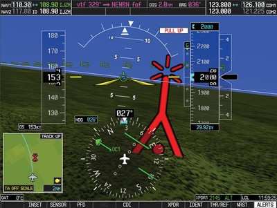
When an aircraft comes too close and the TCAS has calculated a collision, then a sound will play in the cockpit which informs the pilot on what to do. Both aircrafts TCAS Systems communicate with each other and create a so called Resolution Advisory (RA). The pilots will hear this RA as aural warning like Climb, Climb or Descend, Descend. Additionally on the PFD, the primary flight display, which provides the pilot with information like altitude, attitude, vertical speed, speed and more, there will be marked what vertical speed should be flown to avoid a collision.When the threat is over, a sound will play: Clear of conflict.

 |
| Here you see when a TA (Traffic Alert) and a RA (Resolution Advisory) is issued by the TCAS. |
Ok, you got the icons, let's go to the Labels of the icons. Here's the image from before again:
The numbers says what altitude the other aircraft is, relatively to his own aircraft. So, when you are at 2000 ft, +10 would mean 1000 feet above you. -05 means 500 ft below you.
The arrow says if the aircraft is descending or climbing at the moment. Up means climbing and down means descending.
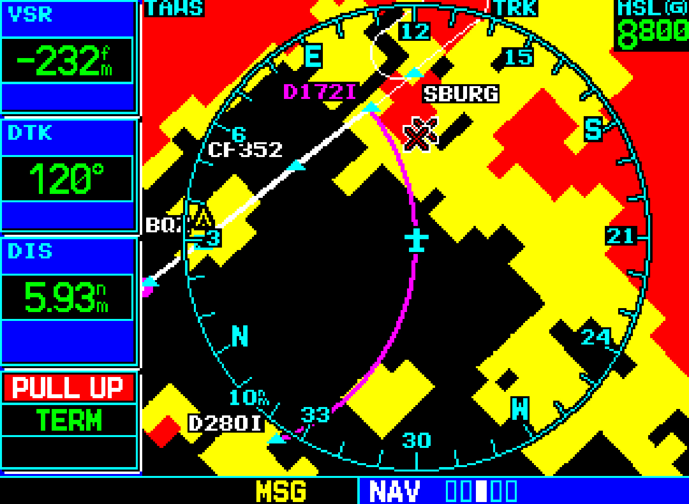
TAWS
TAWS stands for Terrain Awareness and Warning System. It provides the pilot information about the terrain surrounding his aircraft. It is usually displayed on the ND or MFD of an Aircraft. All modern Airliners and many General Aviation Aircraft are equipped with this technology.
 |
| TAWS on Garmin GPS |
By coloring the Map in different colors, pilots get a better situational awareness about their altitude and CFITs (Controlled flights into Terrain) can be significantly reduced.
Let's talk about the colors: I think it's pretty obvious what the different colors mean, but here's a picture to show it:

There is also a similar version of the TAWS, called Enhanced Ground Proximity Warning System (EGPWS). Here's a picture:

On the ND/PFD the EGPWS looks like this:
 |
| Very similar to the TAWS |
Garmin invented a special TAWS named Synthetic Vision. They use it in their Garmin EFIS (Electronic Flight Instrument System) as background for the PFD. It's like flying in a flight simulator in a real plane. Actually it's a 3D TAWS.
 |
| The Synthetic Vision even shows Runway Position |
 |
| The Synthetic Vision also shows Obstacles like Antennas and power lines. |

It is also good to know that the data for the TAWS is not provided by real time radar data, but from pregenerated elevation data files.
GPWS
GPWS stands for Ground Proximity Warning System and is usually equipped on airliners. It consists a set of aural advisories and warnings related to the surrounding terrain which will be played in the cockpit in different situations. The GPWS works with real time radar data and works at an maximum altitude of 2500 ft AGL (Above Ground Level).
The GPWS usually contains these aural warnings:
- Too low, terrain The "Too low" warnings will be played if the aircraft is low and not in landing configuration where Flaps and the gear is required.
- Too low, flaps
- Too low, gear
- Terrain, Pull up This warns from fast rising terrain that could be a threat to the aircraft.
- Sink rate, Pull up If a specific negative vertical speed (Sink Rate) is reached, the plane will warn the pilot.
- Don't sink When the planes vertical speed goes into the negative shortly after takeoff, this warning will be played.
- Glideslope When on an ILS Approach, the warning will be played if the plane under- or overshoots the runways glideslope.
- Windshear A windshear is a sudden change of wind around the aircraft. This can be, especially at approach and takeoff, very dangerous and can lead to a crash. A windshear can be detected if the Airspeed (KIAS) if the aircraft suddenly rises or falls, whilst the groundspeed (GS) stays similar to that before. At airports windshears can be detected by radar. If this warning is heard during approach, an immediate go around should be performed.
- Bank Angle If the bank angle exceeds 35 degrees, this advisory will be played.
- Altitude Advisories Those are the callouts you hear when approachingthe runway. They usually start at 2500ft and end at 5ft in all big airliners:
2500
1000
500
400
300 / 100 above / Approaching Minimums
200 / Minimums, Minimums / Decision height
100
50
40
30
20 (With "retard" on Airbus)
10
5
In many small aircraft this list is smaller. They often start at 500 and end at 100.

Comments
Post a Comment